November 17, 2013
Day 5: Going up!
After a few days on the mountain, I have become ann amateur expert on Orizaba weather. It goes something like this: sun, overcast, sun, overcast, snow, clear, cloudy and clear again. Needless to say, if you don't like the current weather just wait a few minutes.
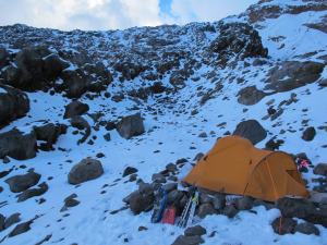
I hit the tail early hoping to get to high camp before the sun got too high and hot (during the sunny period of weather. I made steady progress stopping only a couple times along the way. By the time I reached our tent, I was hiking in just a short sleeve shirt! Of course, the cloudy weather rolled in and a few minutes later I was in all my layers.
I set up our second tent while I waited for Ryan and the rest of the team then crawled in and relaxed for nearly an hour. I brought up a bag of potato chips and it felt more like I was at home than at 15,000'.
I am amazed at the similarities between this area and the Cascades in Washington state. Big volcanoes tower above the surrounding landscape. It make sense after all, the Pacific plate is ramming into North America all along the west coast from where I sit now all the way to Alaska. Interestingly however, Orizaba is 4,000' taller than its cousins in California and Washington.
I had a nice inReach SE conversation with Chip from DeLorme and his family. It was fun to text across thousands of miles.
Now, its dinner, sleep and a 3 am departure for Orizaba's summit.
Image: Our high camp home!